interkriti®
YOUR GATEWAY TO CRETE
HOME
CRETE FACTS
NAVIGATE
EXPLORE

Agia Galini
Triopetra
Kissamos
Chryssi Isl.
Agia Marina
Balos
Gavdos isl.
Georgioupolis
SAMARIA
IDA Mtn
Palaiochora
Agia Roumeli
Sfakaki
Bali
Kalamaki
Matala
Lassithi
Plateau Lendas
Tsoutsouros
Vianos
Myrtos
Sfakia
Plakias
Ierapetra
Makrygialos
ZAKROS
Vai
Sitia
Agios Nikolaos
Elounda
MALIA
Hersonissos
Gouves
Chania
Rethymnon
Heraklion
GORTYN
FESTOS
KNOSSOS
|
|
Crete
List Grid Map
Found
116
- Showing :
41 - 60
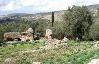
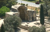 Gortyn archaeological site at 11.5km (SE) Saint Titus church at Gortyn bears the name of the Apostle Titus, attendant of Apostle Paul, who was appointed as the first Christian bishop of Crete. It is one of the most important Byzantine monuments in Crete. The name was given to the ruined church by the excavators in the beginning of the 20th c., as they considered it to be the site of the saint’s martyrdom. After the discovery of the new Great Early Byzantine Basilica, just outside the village Mitropolis, its excavators have proposed that as the original bishopric basilica, as it is a century earlier than this, which in the local tradition is named and celebrated after Virgin Mary, “Kera”. The church has the plan of a three aisled inscribed cross with a low vault. It has been built of ashlar limestone. It has a narthex to the west and five entrances three of which form the trivelum with two columns. There were pillars instead of columns. Its architectural features date its foundation in the 2nd half of the 6th c. AD. Image Library
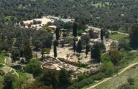 Messara, Iraklion South at 11.6km (SE) Located in the valley of Messara, Gortys or Gortyn (GR: Γόρτυς or Γόρτυνα) is a must visit for all visitors to Crete. It was inhabited during Bronze Age times, but its rise to glory came almost a millennium after the downfall of the 'Minoans'. Gortyn was a prosperous city from around the middle of the 5th century BC through to the early 9th century AD, when it was finally destroyed by the Saracens (824AD), never to be rebuilt.
Image Library
 Amari, Rethymnon at 11.7km (W) The village of Apodoulou is located 55 km from Rethimno at an altitude of 450m. Remains of an extensive centre of the Old Palace period (1950-1700 B.C.) have been uncovered.at the site called Gournes, near the village of Apodoulou, at the west foot of Psiloreitis. The site dominates the Amari valley and controls the main route to the Messara plain. Excavations have brought to light three building complexes while tholos tombs of the Postpalatial period (1380-1200 B.C.) have also been located in the adjacent area. The first excavations on the site were carried out by S. Marinatos in the 1930's. During World War II it was excavated by the German Archaeological Institute, under the direction of E. Kirsten. Since 1985, systematic excavations have been carried out by the Greek Ministry of Culture in collaboration with the University of Naples. The most important monuments on the site are: Building A. It lies on the east side of the hill, to the south of the massive retaining wall. It had two storeys, as is indicated by the two preserved steps of a staircase. Decades of pithoi and other vases found on the ground floor suggest that it was used for storage. The house was destroyed by fire which followed an earthquake. Building B, located to the north of the retaining wall. It is a complex of rooms which originally communicated with Building A. Building C. It lies to the east of house A and belongs to a later phase of the settlement. Tholos tomb at Sopatakia. Tholos tomb with dromos, lying to the east of the road that leads from Apodoulou to Nithavris. The dromos is 7 m. long and the chamber has a diameter of 3.10 m. Three larnakes were found inside the burial chamber. Dated to 1380-1200 B.C. Source: The Hellenic Ministry of Culture 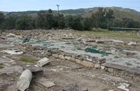 Gortyn archaeological site at 11.7km (SE) This unique monument has been excavated in the last thirty years. It is located on the road between the Saint Titos Church and the village Mitropolis. It is the largest early Byzantine basilica in Crete and among the largest in whole Greece. In early Byzantine period it was the cathedral of the city. The first five-aisled basilica was erected here in the early 6th c., in the years of the Emperor Justinian and stood for about 70 years. The central aisle had a mosaic pavement decorated in geometric patterns and animals. It is believed that there were mosaics of stone and glass tesserae on the walls, too. The other aisle had pavements of limestone slabs. The columns were made of white and gray white marble. Of great importance is the pulpit, which resembles that of Saint Sophia in Constantinople. It was a high exedra on low columns and two stairs for ascent and decent. The choirs stood under the exedra. After the destruction of the first basilica in 620 AD, a new basilica was built over its ruins in the time of the Emperor Heraclios. This basilica, following the fortune of the whole city, was destroyed after the strong earthquake of 670 AD.
Image Library
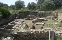 Gortyn archaeological site at 11.8km (SE) The sanctuary of the Egyptian deities (1st-2nd centuries A.D.) is the only one, in the whole island, which is dedicated to the Egyptian gods Isis, Serapis and Anubis - Hermes although it is known that those gods are worshiped in other cities. The sanctuary consists of quadrilateral nave, arcade on the west, underground crypt in the south and a cistern outside east of nave. In the central alcove stood the statue of Serapis and the side statues of Isis and Hermes - Anubis. In the southern part of the temple was oblong space, underground crypt purification and a small cictern. The final construction phase of the temple dates to the 1st / 2nd century. AD, in accordance with dedicatory inscription. Image Library
 Anogia at 11.9km (N) The artistic events, which take place every year in the first week of July at the same place called Fourni and in the Cretan village of Anogia. The poet, songwriter and singer from Anogia, who they call "Loudovikos from Anogia" wants to make the history of the young martyr, who supersedes his fear in love known to the public. And because 1.900 years have passed since the martyrdom of Yakinthos, he decided to honor the Saint of Love and sing together with him of the poetry of love.(www.yakinthia.com)
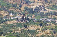
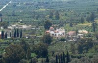 Village in Messara plain at 11.9km (SE) Mitropoli (GR: Μητρόπολη) is a small village in the archaeological site of Gortyna in Messara plain. The village is mentioned for the first time in the Ducal archives of Candia in 1368 and later in the census of 1577 by Fr. Barozzi and in 1583 by Castrofylaka. Early mention of the settlement is to document the Ducal Archive of Candia in 1368, also mentioned by Fr. Barozzi in 1577 with the name and the Mitropoli Kastrofilakas in 1583. According to the census of 2001 it has 382 inhabitants. Main occupations of the inhabitants is the cultivation of vines, olives, vegetables, cereals and citrus fruits. At its north borders are located the ruins of the first cathedral of St. Titus, in which it owes its name.(Mitropoli = Cathedral). Image Library
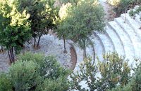
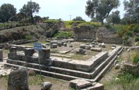 Gortyn at 11.9km (SE) The Temple of Apollo Pythios (Pythian Apollo) located in the center of the ancient Agora, was excavated in 1887 and was the largest temple and the religious center of ancient Gortyn until the introduction of Christianity and the founding of the basilica of St. Titus around 500 AD. The first building of the seventh century. BC was a four-sided enclosure with four wooden pillars in the center to support the roof. The exterior walls and stairs of the crepis were covered with archaic inscriptions. In the Hellenistic period a monumental anteroom was added while columns with inscriptions were placed between the pillars. Alterations and additions were made during the Roman period. Outside the temple was built a magnificent altar on a stepped base while in the west of the temple was built a small theatre. In the middle Byzantine period in the vicinity of the temple, which had been abandoned, were built houses and aqueducts. Many finds have been made in the temple among which the colossal statue of Apollo Pythios and many inscriptions with administrative and law content of the Archaic and Hellenistic period. Dates: 7th c BC; Hellenistic; 2nd c AD. Image Library
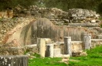
 Kenourgiou, Iraklion at 12km (E) Priniás (GR: Πρινιάς) is a small village located 35km southwest of Iraklion town and 4km from Agia Varvara, at a height of 610 m above sea level. The village of Prinias lies on the border of three regions: Malevizi, Kenouriou and Monofatsi, and is recorded as forming part of all three regions in the censi. 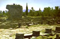 Gortyn at 12km (SE) The Praetorium was the seat and residence of the proconsul of Crete. It is divided into two parts: the administrative section, in which the central building is the basilica, and the more "private" sector. The preserved ruins are dated to the 2nd century A.D. and seem to have been repaired in the 4th century A.D. This totally excavated building is the largest in the whole City of Gortyn. The earliest constructions have suffered successive alterations in a long period of eight centuries. New structures were erected on the ruins of the earlier sometimes incorporating parts of them. In the 1st c AD the Praetorium consisted of a peristyle court 1000 sq.m. and large halls to the north and west. This first Praetorium was destroyed by an earthquake in the time of the Emperor Trajan (early 2nd c AD). It was reconstructed and a large Thermai complex was built at its east side. Some years later a large temple dedicated to the Augusts was built further at the east part. To the west of the Thermai the juridical basilica continued to function under a judge’s responsibility according to the inscriptions found there, and statues of the emperors and other officers were still standing there. All these famous buildings were destroyed by the large earthquake in 365 AD. In 383 the consul Oecumenius Asclepiodotus Dositheus, agreeing with the capital of the empire, took care of the construction of the new Praetorium. Image Library
 Gortyn archaeological site at 12km (SE) The Great Nymphaeum (Nymphaion GR: Νυμφαίον), located to the north of Praetorium, was a marble construction with a covered cistern and fountains. Statues of Nymphs stood in the niches. The area of the remains is closed to the public but visitors can see it from a distance.
Image Library
 Kenourgiou, Iraklion at 12.2km (E) Moúlia (GR: Μούλια) is a village in Kenouriou county, located three and a half kilometers away from Agia Varvara town and 32 km from Iraklion at an altitude of 640 m above sea level. Moulia is an old village as we come across a reference to it in a document dated in 1248, where the settlement is recorded as belonging to the archbishopric of Crete. Another reference is found in a legal agreement established in 1411. The name figures in all the Venetian censi of the 16th and 17th centuries, as well as in the Turkish and Egyptian censi. In 1881, it forms part of the municipality of Zaros with about 180 inhabitants, and again in 1900. As of 1920 it is a commune in its own right, and today with the lower village of Kato Moulia it counts over 550 inhabitants. The main church of the village, with wall paintings, is that of the patron saints, Saints Peter and Paul, and there is a village feast on the 29th June, in their honour. The lovely chapel of Zoodochos Pigis is also well worth a visit.
 Gortyn archaeological site at 12.3km (SE) It lies at the south eastern part of the city and it is considered to be largest of all theaters in Gortyna. Although it is not yet excavated, it is believed that it had a two storeyed stage and its cavea was supported by 56 arches. The statue of the seated philosopher that we see next to the exhibition hall of the archaeological site was found here.
Image Library
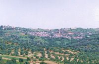
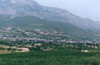 Kenourgiou, Iraklion at 12.6km (E) Agia Varvára (GR: Αγία Βαρβάρα) is a town built along the road between the Messara plain and the Malevizi region at the highest point (580 m). The town enjoys a unique location with a splendid view into the Malevizi region, and a cool climate, particularly pleasant during the hot summer months. It produces first-rate fruit and vegetables. Because of its strategic location on the main north-south axis, the town was often exposed to fierce battles. A famous warrior, Mathiou Kapitakis or Mathioudakis was born here: he fought side to side with Karaiskakis and was killed at Faliro. His comrade-in-arms, Logios, was the hero of Aghios Thomas. As you reach the village, on the north side there is a rock with a chapel dedicated to Profitis Ilias. On this rock -which used to be twice as large but part of it fell off at the beginning of the 19th century- there used to be an ancient temple. Nowadays, the visitor can find every kind of commodity and facility on hand at the modern town of Aghia Varvara. In summer a special 'tsikoudia' feast, and in early spring a carnival feast are organized by the Cultural Association of the town. At the centre of the town, there are two churches - one old and one new - both dedicated to the patron saint, Aghia Varvara. Three Byzantine churches are also well worth a visit: Profitis Ilias, Aghios Giorgos and Aghios Ioannis, and of course the old monastery of Aghia Pelagia by the cemetery. 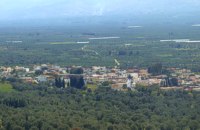 Messara, Iraklion South at 12.6km (SE) Agioi Déka (GR: Αγιοι Δέκα) is a town with 820 inhabitants in the plain of Messara, 170m above sea level, 43 km from Heraklion town and very close to the archaeological site of Gortyna. Its people are occupied mostly in agriculture - vines and olive trees. In the area there is is the oldest olive grove in Crete. The town is built on the ruins of the ancient town of Gortyn where the Holy Ten Martyrs have been martyred. 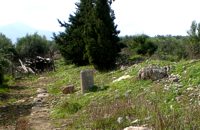 Gortyn archaeological site at 12.6km (SE) The Hippodrome was located in the south part of the city of Gortyn, and was surrounded by columns. The central section was 374 metres long and 60 metres wide. Our information on the site is insufficient for the reason that there was never a systematic survey, or even a small excavation. What we see today of this magnificent monument are only some parts of columns and capitals.
Image Library
 by Richard Ellis at 12.7km (NW) This is my log of the E4 long distance walk along the spine of Crete from East to West - it is intended to be a useful resource for others who are contemplating a similar walk along the E4 in Crete; it is not intended in any way to be a complete route guide.
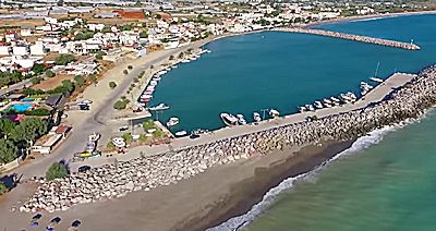 Messara bay, Iraklion South at 13.2km (SW) Kokkinos Pirgos (GR: Κόκκινος Πύργος) is a small coastal community, 2km away from Timbaki with a nice, long sandy beach, one of the longest in Crete, and a clear transparent sea. The part of the beach to the north west of the harbour is called Makrimaliana (or Kakoskalo) and the south east part of it is called Katalyki . The harbour in front of the village of Kokkinos Pirgos, offers docking facilities for sailing and fishing boats. There are hotels, restaurants, bars, etc. across the harbour and along the beach. You can always find good fresh fish in the taverns of the village. Kokkinos Pirgos (meaning red tower) , took its name from a castle that use to be there during the Middle Ages, which was built by red clay earth.
Image Library
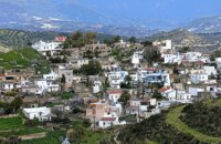 Messara, Iraklion South at 13.5km (SW) Kamilari is a quiet, traditional village, with a panoramic view to the endless olive groves of the Messara valley on the one side, and to the Libyan sea on the other side. It has been inhabited since the Minoan period. One of the seven wise men of the ancient world, Epimenidis, a great wise man and a soothsayer, lived in a small community outside Kamilari, called Metohi.
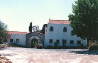 Malevizi, Iraklion at 13.5km (NE) The monastery of Aghios Georgios the Gorgolainis (GR: Αγιος Γεώργιος Γοργολαΐνι) is located on an altitude of 400 m close to the Kato Asites village. It survived through several revolutions and wars during the Ottoman occupation. |
|
|
|
| ||
)
C
O
N
T
E
N
T
S
O
N
T
E
N
T
S