interkriti®
YOUR GATEWAY TO CRETE
HOME
CRETE FACTS
NAVIGATE
EXPLORE

Agia Galini
Triopetra
Kissamos
Chryssi Isl.
Agia Marina
Balos
Gavdos isl.
Georgioupolis
SAMARIA
IDA Mtn
Palaiochora
Agia Roumeli
Sfakaki
Bali
Kalamaki
Matala
Lassithi
Plateau Lendas
Tsoutsouros
Vianos
Myrtos
Sfakia
Plakias
Ierapetra
Makrygialos
ZAKROS
Vai
Sitia
Agios Nikolaos
Elounda
MALIA
Hersonissos
Gouves
Chania
Rethymnon
Heraklion
GORTYN
FESTOS
KNOSSOS
|
|
Crete
: Towns & Villages
List Grid Map
Found
52
- Showing :
41 - 52
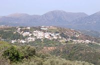
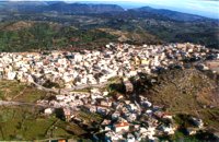
 Pediada, Iraklion at 20.7km (E) Kastamonitsa (GR: Κασταμονίτσα) is 7 km away from Kasteli, has 356 inhabitants and lies at 520 m above sea level, in the foothills of the Afendi mountain (1578 m), with the Dikti mountain in the background. The village is not mentioned in the Venetian registers of the 16th and 17th centuries, nor in the Turkish census of 1671. It is possible that the name is related to that of Kastamoni in Asia Minor: refugees, driven out of their land by the Turks, may well have come and settled here, giving their new home the same name as their old one. But it is impossible to establish a precise date. The Church of the Koimisi tis Theotokou (Dormition of Our Lady), located in the cemetery of the village, has wall paintings of the 14th century and points to a settlement here during the Venetian period. However, as we said before, the village is not mentioned in any Venetian census. The first reference is to be found in an Egyptian census conducted in 1834, where the village of Kastamonitsa is said to have 35 Christian families. And again in 1881, the village is said to have 320 Christian residents; no Turkish families are mentioned. The location of the village on the way to the natural fortress of the Lassithi plateau which protects all of Eastern Crete, turned the area into a battlefield during the last century. The Egyptian Pasha Hassan tried to invade the Lassithi plateau in 1822. The rebels cut him off between Krassi and Kastamonitsa, fighting him so well that he was forced to change his strategy and invade the plateau through its south side (Viannos and Ierapetra). Other fierce battles took place in and around Kastamonitsa during the 1866-67 rebellions. Finally Omer Pasha, known as the Attila of Lassithi, found a way up through the glen at Geraki where an betrayer showed him the way. A clay cast has been found in Mesarmi. It is elliptical in shape and has a width of about 0.25 m, and has a plaited decoration. A round glass vessel was also found at Xidiano Seli. 4 km out of the village you get to a lovely spot known as Mesada, where traditional celebrations take place on Easter Tuesday.The village boasts of several kapheneions and a taverna in the main square. There is an active cultural centre, that organizes events especially in the summer. The most important and traditional feast is held on July 7th in honour of Aghia Kyriaki. Image Library
 Pediada, Iraklion at 20.8km (E) Askoi (GR: Ασκοί) is small village in the municipality of Kasteli has 315 inhabitants. It lies in the foothills of the Dikti mountain, 11 km to the east of Kasteli and 8 km from Lyttos. Fr. Barozzi mentions it as Ascus, in the Pediada district, in 1577. Recently a ritual clay figurine of the Mid-Minoan period was fortuitously unearthed on a peak close to the village. The remains of a large building belonging to a peak sanctuary have been excavated at Amygdalokefalo to the NE of the village. A reference in a contract of 1271, mentions how Petri Comarii from the village (casali) Maski owes Ruggerino Temisano, resident in Chandax, 25 «mistata» of good Cretan wine from his vineyards in Maski. Among other natural beauties, the ravine at Aski is well worth seeing. On December 4th the village has a typical Cretan feast to honour Agia Varvara. And as in every Cretan village, raki and ‘mezedes’ are always available at the kafeneions. Image Library
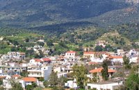
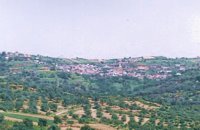 Kenourgiou, Iraklion at 20.8km (SW) Moúlia (GR: Μούλια) is a village in Kenouriou county, located three and a half kilometers away from Agia Varvara town and 32 km from Iraklion at an altitude of 640 m above sea level. Moulia is an old village as we come across a reference to it in a document dated in 1248, where the settlement is recorded as belonging to the archbishopric of Crete. Another reference is found in a legal agreement established in 1411. The name figures in all the Venetian censi of the 16th and 17th centuries, as well as in the Turkish and Egyptian censi. In 1881, it forms part of the municipality of Zaros with about 180 inhabitants, and again in 1900. As of 1920 it is a commune in its own right, and today with the lower village of Kato Moulia it counts over 550 inhabitants. The main church of the village, with wall paintings, is that of the patron saints, Saints Peter and Paul, and there is a village feast on the 29th June, in their honour. The lovely chapel of Zoodochos Pigis is also well worth a visit.
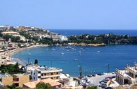 Malevizi, North - West Iraklion at 21.9km (NW) Agia Pelagia lies 20km west of Iraklion. The bay of Agia Pelagia is ideal for combining sea sports with relaxation. The visitor will find well trained instructors that offer lessons for sea sports such as water-ski, wind surf, canoe. Agia Pelagia offers unique high standard hotel facilities as well as many small hotels and pensions.
 Pediada, North - East Iraklion at 22.5km (E) The most popular tourist resort in Crete. Nice beaches, sights and facilities for all tastes and ages. Together with Malia, are the party places for young visitors. Close to Hersonissos there are three small traditional village, those of Piskopiano, Koutouloufari and Old Hersonissos.
 Malevizi, North - West Iraklion at 23.9km (NW) A traditional village - birth place of Domenikos Theotokopoulos (EL GRECO) - with many pottery and weaving workshops. Close to the village is a small beach with taverns and a large hotel resort. Fodele is known also for its quality orange production.
 Milopotamos, Rethymno at 25.7km (W) Anogia is a mountain town with 2500 permanent residents and is 55 km away from Rethymnon and 36 km from Iraklion. The name Anogia, means "high place - Ano Gi", is connected with the location that is built, in altitude of 700 m. Hospitable and pleasant residents have to tell a lot of old stories that have marked the tradition and the culture of the village. Anogia is a well-known village historically for its resident's resistance to the conquerors, Turkish and Germans.
Image Library
 Kenouriou, South Iraklion at 26.3km (SW) Zaros (Greek: Ζαρός), at an altitude of 340 metres, is a town with a lake and gorge nearby. It has a couple of hotels and it is 44 km from Heraklion at the southern foothills of Mountain Psiloritis. The population of 3,400, produce olive oil, sultanas, vegetables and spring water. There are a couple of fish farms that serve both trout and salmon. In Zaros, there are cafes near Lake Votomos, as well as a tavern that serves fresh trout called I Limni (The Lake). Close by is Rouvas Gorge, which is part of the Psiloritis mountain range and is on the hiking route known as the E4 European Walking Path. Nearby Zaros are traditional water mills which have been working since the 16th century, as well as archaeological sites and monasteries. Zaros is also famous for its water "ZAROS" bottled by a company called Votomos SA. 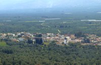 Messara, Iraklion South at 27.4km (SW) Agioi Déka (GR: Αγιοι Δέκα) is a town with 820 inhabitants in the plain of Messara, 170m above sea level, 43 km from Heraklion town and very close to the archaeological site of Gortyna. Its people are occupied mostly in agriculture - vines and olive trees. In the area there is is the oldest olive grove in Crete. The town is built on the ruins of the ancient town of Gortyn where the Holy Ten Martyrs have been martyred. 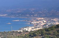 Pediada, North - East Iraklion at 27.7km (E) The famous tourist resort with all types of accommodations. Great beaches and a lively party atmosphere particularly in August. Becomes pretty quiet and peaceful during the rest of the season and there is a nice and picturesque part of the old village that preserves the traditional character. Malia has also a significant agricultural production and is famous for its bananas, potatoes and bottled water.
 Pediada, Iraklion at 28km (E) Krassi is a small village 47 Km's from Iraklion and 17 km from Malia at an altitude of 600 m.asl, on the way to Lassithi plateau, and is administratively part of the Municipality of Malia. The village is one of the prettiest in Crete, with a lot of springs. Due to the free running water , it is covered with walnut trees, plane trees and all kinds of vegetation. Next to the spring in the middle of the village is one of the oldest and biggest plane trees in Crete (its root has a circumference of 22 meters!).  Village in Messara plain at 28.7km (SW) Mitropoli (GR: Μητρόπολη) is a small village in the archaeological site of Gortyna in Messara plain. The village is mentioned for the first time in the Ducal archives of Candia in 1368 and later in the census of 1577 by Fr. Barozzi and in 1583 by Castrofylaka. Early mention of the settlement is to document the Ducal Archive of Candia in 1368, also mentioned by Fr. Barozzi in 1577 with the name and the Mitropoli Kastrofilakas in 1583. According to the census of 2001 it has 382 inhabitants. Main occupations of the inhabitants is the cultivation of vines, olives, vegetables, cereals and citrus fruits. At its north borders are located the ruins of the first cathedral of St. Titus, in which it owes its name.(Mitropoli = Cathedral). Image Library
|
||
|
| ||
)
C
O
N
T
E
N
T
S
O
N
T
E
N
T
S